 HURRICANE ALLEY
Graphic made using HurricaneWatch 98
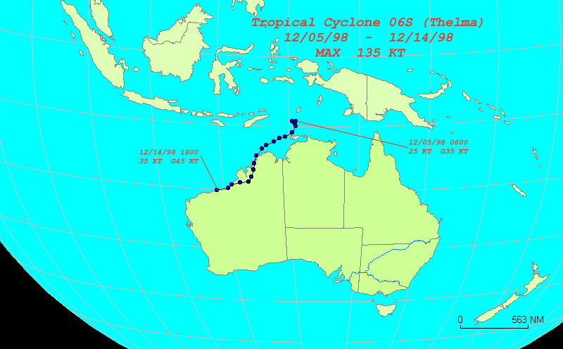
Adv. # Date Time Latitude Longitude Sustained kts Gust kts Movement Speed kts 1 12/05/1998 0600 9.2 S 130.5 E 25 35 2 12/05/1998 1800 9.2 S 131.0 E 25 35 090 2.5 3 12/06/1998 0600 9.6 S 130.9 E 45 55 194 2.1 4 12/06/1998 1800 9.4 S 130.8 E 55 70 334 1.1 5 12/07/1998 0600 10.0 S 131.0 E 90 110 162 3.2 6 12/07/1998 1800 10.9 S 130.5 E 115 140 209 5.1 7 12/08/1998 0600 11.6 S 129.5 E 120 145 234 6.0 8 12/08/1998 1800 11.8 S 128.7 E 135 165 256 4.0 9 12/09/1998 0600 12.3 S 127.9 E 130 160 237 4.6 10 12/09/1998 1800 12.9 S 126.8 E 130 160 241 6.1 11 12/10/1998 0600 13.4 S 126.1 E 125 150 234 4.2 12 12/10/1998 1800 14.5 S 125.3 E 120 145 215 6.7 13 12/11/1998 0600 15.7 S 124.9 E 90 110 198 6.3 14 12/11/1998 1800 16.7 S 124.7 E 60 70 191 5.1 15 12/12/1998 0600 17.8 S 124.4 E 35 45 195 5.7 16 12/12/1998 1800 18.6 S 123.9 E 40 50 211 4.7 17 12/13/1998 0600 18.8 S 122.6 E 35 45 261 6.2 18 12/13/1998 1800 19.2 S 121.3 E 35 45 252 6.5 19 12/14/1998 0600 19.7 S 120.7 E 35 45 229 3.8 20 12/14/1998 1800 20.2 S 119.0 E 35 45 253 8.4 FINAL WARNING ISSUED 12/14/1998
![]()
Hurricane Alley Home
Comments:
This site is trakked by Net-Trak!
®© TOMB, 1998,1999.